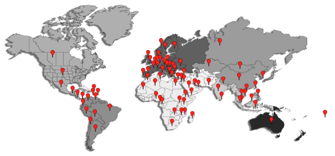
OpenGTS is now being used in over 110 countries/territories around the world.
Here is a list of some of them:
... and is being used to track 1000's devices around every Continent:
- Africa
- Antarctica
- Asia
- North America
- South America
- Europe
- Australia
|
We wish to thank the following individuals for their contribution in improving the OpenGTS project:
- Andrey Troitskiy (MegaPage) - Updated "dcserver.dtd" with latest XML configuration.
- Anthony George (EMS Resource Center) - Mapstraction integration/support.
- Amanda L. Flynn - Graphic Design.
- Assaad Mouawad - Help getting GeoServer integrated with OpenLayer.
- Astra Telematics - Support for "Astra" DCS.
- Aykut Kara - Turkish localization.
- Berry Jansen - Latitude/Longitude encoding accuracy improvements.
- Christos Prassas - Greek localization.
- Clifton Flynn - Conversion of code to support an XML-based web-service.
- Eduardo Robles - Spanish localization.
- Eugene A.Lukianov - Russian localization.
- Humberto Bonisson - Portuguese localization.
- Jeremy Parniuk - Help with XML DTD implementation, and other data integration.
- Jovanni Cutigni - Updated Javadocs.
- Juan Carlos Argueta - Added route-line arrows on GoogleMaps.
- Krzysztof Kasza - Polish localization.
- Mario Viara - Slovak localization.
- Mihai Csaky - Romanian localization, GISGraphy support.
- Nenad Babajic - Serbian localization.
- Peter Jonas - Mapstraction testing/support, German Localization.
- Pierluigi Bucolo - Italian localization.
- Ronald Prijs - Dutch localization.
- Rudi Heitbaum - Code improvement patches.
- STefan Mayer - Battery level/voltage support in "gprmc" DCS.
- Stuart Langridge - 'sorttable.js' JavaScript for sortable table columns.
- Thomas Cozien - French localization.
- Totyi Ferenc - Hungarian localization.
- Franjieh El Khoury - Cell-Tower location information parsing for "tk10x" DCS.
If you are a device manufacturer and are interested in having your remote device supported by
OpenGTS, please feel free to contact us by email at the address below.
Contact: devstaff@opengts.org
|